
News
FG Collaborates with Indian Government on Geospatial and Carbon Mapping
FG Collaborates with Indian Government on Geospatial and Carbon Mapping
By: Michael Mike
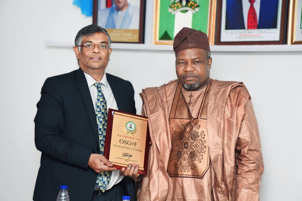
The Federal Government is to collaborate with the Indian Government on geospatial mapping and technical expertise exchange, remote sensing, carbon mapping, and auto imagery.
The collaboration with the Indian government is to be undertaken by Nigeria through the Office of the Surveyor-General of the Federation.
This was made known when the Surveyor-General, Surv. Abuduganiyu Adebomehin received the Indian High Commissioner to Nigeria, Ambassador Gangadharan
Balasubramanian on Friday.
The Indian High Commissioner stated that the reason for the visit was to seek collaboration on behalf of the Surveyor General Office of India and the government of Nigeria on the new geospatial policy inaugurated by India, by reaching out to major countries.
He highlighted India’s strength in remote sensing and space capabilities due to the satellite coverage of the country for geographical mapping. He stated that Hydrography, Remote Sensing, Surveying training, and technical expertise exchange are key areas in which both countries can work together.
The Ambassador reiterated the use of Artificial Intelligence to provide auto imagery as India has a high resolution of images. Hence, the proposed collaboration with Nigeria, so there can be harmonization of data sets. He looked forward to receiving a copy Memorandum of Understanding from Nigeria.
He said that India is ready for a partnership and cooperation with Nigeria, and he assured that the pending Memorandum of Understanding on Hydrography between India and Nigeria which is pending would be attended to soon.
Responding, Surveyor-General of the Federation described the office as the only one that defines Nigeria. He affirmed the office is very much available for collaboration in the geospatial area, leveraging India’s strength in joint mapping using their imagery and other related matters. He said now that the Indian government has established its geospatial data infrastructures while Nigeria is still trying to establish its own that is the area the two countries can collaborate.
He said Nigeria can take advantage of India’s satellite to capture the carbon underground and its location so that Nigeria can be proud of what they have. “Another area of the proposal I want India to come in is the area of Agriculture, to see how India’s geospatial data can be applied in the area of foods production and security,” he said.
He said that the office had benefitted from the India technical expertise training in the past and appealed for the reactivation of training as human capacity development is key. He promised that the collaboration would be pursued with all vigour to see how it could be beneficial to both countries.
FG Collaborates with Indian Government on Geospatial and Carbon Mapping

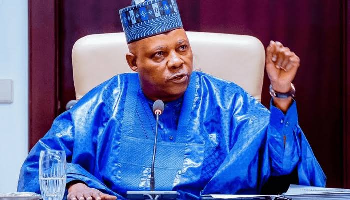
Kashim Shettima: Of Betrayal, Power, and Survival.
By: Inuwa Bwala.
“March has returned, and with it the Ides. Beware the men who call you brother.”
Julius Caesar was perhaps Rome’s most trusted general. He crossed the Rubicon for Rome, conquered Gaul for Rome, and pardoned enemies for Rome.
Yet it was neither Gaul nor Pompey: his avowed rivals, that killed him. It was Brutus: his friend, and confidant yet his protégé, who was described as “the noblest Roman of them all.”
Julius Caesar did not slump and died because the daggers were too many, rather, bacause he noticed the person he least expected could betray him amongst those stabbing him: Brutus. In utter shock and disbelief, Caesar slumped, but not before he uttered the word,”And you too Brutus?”.
There is no doubt that, Kashim Shettima was Borno’s most tested governor. He walked into boiling areas, when others fled the state. He rebuilt schools bombed by Boko Haram. He chose to stay in Maiduguri when Abuja offered comfort.
As Vice President, he has carried himself as a true statesman abs the face of the Tinubu administration at national and international meets.
He always speaks of “the sanctity of human life” and calked for swifter and total mobilisationagainst terror.
Yet today, whispers from Borno and Abuja suggest the daggers are not in the bush like that of Boko Haram, they are in the hands of his kinsmen, those he hold family meetings and political meetings with.
Those who could read between the line, may be able to tell, when Shettima gave an anecdote at a recent public function, about the visit by his kinsmen to his boss, Bola Ahmed Tinubu, just three months into the life of the administration.
Like Brutus and the conspirators of the Shakespearean fame, who claimed they did not hate Caesar, but loved Rome more, those who visited Tinubu claimed to love Nigeria more and her President, abd not brcause thry hated Shettima.
Brutus in particular played on a so-called republican pride and his fear of tyranny, which he used in convincing himself that betrayal was patriotism. He struck to “save” Rome.
Shettima’s own “Brutuses” use a different script, relying on Shetyima’s perceived ambition and the attendant battle to keep himself in the balance of power as an alibi.
And in the face of contending forces, they recruited people to plsy out the cards, while remaining in the shadows. The charges may appear different with that if Caesar, but the intents are same. And while still smarting from the Muslim-Muslim debacle, Shettima had hradly setyled in office when they began to spread rumours of him, being too Borno, not enough to be a northerner. Too ambitious, fetish, independent minded and growing too popular. One thing they could not take away from him though us the fact that Shettima is intelligent, shrewd and a master schemer, which his boss knows too well.
I had cause to warn of this years ago seeing Shettima’s passive refusal to pick between kinsmen in place of statesmen to work with him.
I could see through the plots to denigrate a fine emergent nationalist by linking him with Boko Haram, painting him as fetish, portraying him as a religious and ethinic checkbox, all in a bud to undo him. The weapon when he was govetnor was insurgency, but the weapon now is political naivity and stereotyping . The tactic includes convincing his Kanuri kinsmen to fight him, so that “when Kanuri fights Kanuri, others will win. But beyond that, even his Kanuri brothers seem to have an axe to grind with him.
The painful truth remains, that, Caesar’s killers were senators in the Capitol, but Shettima’s challengers may be his own kinsmen: some of whom, he nentored snd no one can ever convince him that, they could ever work against him. In both cases, the dagger is dipped in familiarity.
It cuts deeper because the hands holding it, are either those he mentored or once broke bread with him.
Caesar died because he ignored omens. Not even Calpurnia, his wife’s dream could deter him. He ignored the soothsayer, and shunned the Senate’s mood, thinking goodwill was a good sheild and armor.
Shettima’s March 2027 is loaded with omens too, arising from fresh attacks by vested interests, intrigues amongst political players, betrayal by kinsmen, espionage by aides and attachees, dissertion by hitherto close allies, manipulations in the media, ethnic or religious profiling, clandestine meetings that without communiqués, but with lethal intents, contending forces in the party who whisper that 2027 needs a “new pairing.” indeed, the ides are here, because a second term is near, and second terms birth daggers.
As governor, perhaps Shettima survived by moving rather faster than conspiracy. He outrun, those who want to either even scores or shake off his dominace, and those people have remained at daggers drawn with him
How Shettima Survives, will definitely be a refrence point in power struggles in Nigeria.
But unlike Caesar who never learnt, Shettima is a good student of Robert Greens 48 Laws of Power, and must have drawn lessons from the falls of others before him.
To survive, Shettima must learn to trust, but audit the Praetorians. Caesar trusted Brutus with his life. Shettima cannot afford blind trust. The INEC database compromise and probe shows how insider access kills. Shettima must do what he did as governor: forensic audits, no sacred cows. As I earlier said, he must have his own policy, which must not be changed simply because some people want to determine its content.
He must learnt to keep the people, his own trusted people, and must not loose, as Caesar lost Rome due to his belief in his personal prowess and capacity. Shettima still owns Borno’s streets and still conttols the larger and more lethal political forces in the North.
He should be able to name the Brutus, but should not become an Antony, whom at Caesar’s funeral sparked civil unrest. Shettima cannot afford chaos. He should have a machinery on ground that will expose the plot, without burning the Forum. He should expedite action in uniting the North, and rally the support of kinsmen, even as a counterforce, or risks allowing the real enemies to win.
Importantly, he should bear in mind, that, the parabolical March is not the end, the ides pass. For Caesar, it ended at Pompey’s statue, but for Shettima, March can end with a stronger alliance. He must do what he told the nation: “We choose light over shadow, and hope over despair”.
The Verdict of History, had
Brutus dying on his own sword, muttering, “Caesar, now be still.” Betrayal did not save the Republic, rather it buried it.
Shettima’s kinsmen face the same choice. They can strike and wait for the verdict of history, or they can sheathe the dagger and remember: the real enemy still sleeps someehere else.
Twelve years ago, I wrote that Shettima’s ides would test Borno. In 2026, I state without fear of contradiction, that, they will test Nigeria.
Caesar ignored the soothsayer because he was in so much hurry. Shettima, as always, may not be in a hurry, but should he decide to, that hurry may yet save him.
Kashim Shettima: Of Betrayal, Power, and Survival.
News
FACT CHECK: No School Attack, No Student Abduction in Kautikari — What Really Happened During the ISWAP Raid
FACT CHECK: No School Attack, No Student Abduction in Kautikari — What Really Happened During the ISWAP Raid
By Zagazola Makama
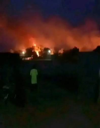
A wave of alarming reports circulating across social media and some online platforms has claimed that Boko Haram insurgents attacked a school and abducted students in Kautikari community of Chibok Local Government Area, Borno State.
The claims, predictably amplified by emotionally charged references to the 2014 Chibok schoolgirls’ abduction, have generated anxiety among Nigerians following developments in the troubled region.
However, a detailed fact-check by Zagazola Makama, based on assessment from field sources, and video evidence from the scene, has found the claims to be entirely FALSE.
According to sources, the incident occurred at about 7:30 p.m. on June 13 when ISWAP terrorists launched an attack on a hunters’ patrol base located within the premises of a disused primary school in Kautikari.
The facility being used by the hunters was not functioning as a school at the time of the attack, nor were students present at the location. Rather, local hunters had established a patrol outpost within the structure, using some of the classrooms as temporary accommodation and operational shelters while supporting troops of Operation HADIN KAI’s efforts in the area.
The terrorists specifically targeted the hunters’ base and not a school populated by students as widely claimed. Initial resistance by the hunters successfully repelled the first assault.
However, the terrorists later regrouped in larger numbers and launched a second attack, forcing the hunters to temporarily withdraw after running low on ammunition.
Military sources disclosed that reinforcement teams comprising troops of the 117 Task Force Battalion from Kwada, supported by a Quick Response Force, local hunters and vigilante personnel, rapidly mobilized to the scene and engaged the terrorists. The coordinated response eventually overwhelmed the attackers and forced them to retreat.
No Student Was Abducted
Contrary to viral claims, there is no evidence that any student was abducted during the attack. Operational reports from the scene recorded no missing students, no reports of schoolchildren being taken away, and no indication that the terrorists targeted an educational institution in session.
Security sources confirmed that accountability checks conducted after the attack found no cases of student abduction.
In fact, the only confirmed casualties were one civilian who was reportedly struck by a stray bullet fired by the terrorists and one member of the Civilian Joint Task Force (CJTF) who sustained a gunshot wound to the arm.
Sources said also that the terrorists set fire to clothing and personal belongings belonging to the hunters stationed at the outpost. No troops were killed or injured during the engagement.
Further undermining the false reports is video footage obtained by Zagazola Makama from the aftermath of the attack. In the footage, one of the affected hunters is seen showing the damaged facility and burnt belongings while lamenting the destruction caused by the terrorists.
The hunter can be heard explaining that the location served as their place of accommodation and operational base.
“This is where we sleep,” he says while pointing to the affected section of the building.
The footage clearly supports military accounts that the target was a hunters’ outpost and not an occupied school hosting students.
The confusion likely arose because the hunters’ base was situated within the premises of a primary school building.
Photographs and videos showing damaged classrooms were subsequently circulated online without context, leading some platforms to incorrectly conclude that a school had been attacked and students abducted.
The result was the rapid spread of misinformation that failed basic verification standards.
Given Chibok’s painful history, any report involving schools and abductions naturally attracts national and international attention. This makes accurate reporting even more important.
FACT CHECK: No School Attack, No Student Abduction in Kautikari — What Really Happened During the ISWAP Raid
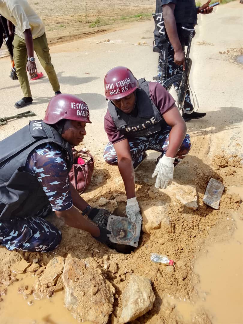
Police Foil IED Attack, Destroy Explosive Device in Zamfara
By: Zagazola Makama
The Zamfara State Police Command says it has successfully foiled a planned attack after its Explosive Ordnance Disposal (EOD) unit discovered and safely destroyed an Improvised Explosive Device (IED) in Tsafe Local Government Area of the state.
The Command said the operation was carried out on Friday at about 4:15 p.m. along the Kunchin Kalgo axis following credible intelligence received through community engagement efforts.
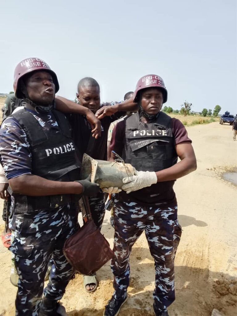
According to a statement issued by the Command, operatives of the Violence Crime Response Unit (VCRU), in collaboration with the EOD team, swiftly mobilised to the area after receiving information about a suspected explosive device planted by bandits.
Preliminary findings indicated that the device was strategically planted along the road with the intent of causing mass casualties among commuters and other road users.
The statement added that the timely response of the operatives led to the safe detection, evacuation and controlled destruction of the explosive device before it could cause any harm.
The Command commended the vigilance and cooperation of local residents, describing community support as critical to ongoing security operations in the state.
It further assured residents that efforts were ongoing to identify, arrest and prosecute those responsible for planting the device.
The police also disclosed that patrols had been intensified across vulnerable areas to prevent similar incidents and ensure the safety of road users.
The Commissioner of Police, A.M. Bello, reiterated the Command’s commitment to sustained operations against banditry and other violent crimes in Zamfara State.
Police Foil IED Attack, Destroy Explosive Device in Zamfara

Troops Neutralise Suspected Kidnapper While Attempting Escape in Plateau

Kashim Shettima: Of Betrayal, Power, and Survival.

ELECTIONS CAN WAIT: SAVING NIGERIA FROM COLLAPSE MUST COME FIRST

Roger Federer’s Shock as DNA Results Reveal Myla and Charlene Are Not His Biological Children

THE PLIGHT OF FARIDA

FAILED COUP IN BURKINA FASO: HOW TRAORÉ NARROWLY ESCAPED ASSASSINATION PLOT AMID FOREIGN INTERFERENCE CLAIMS
-
 News2 years ago
Roger Federer’s Shock as DNA Results Reveal Myla and Charlene Are Not His Biological Children
-
Opinions4 years ago
THE PLIGHT OF FARIDA
-
 News1 year ago
FAILED COUP IN BURKINA FASO: HOW TRAORÉ NARROWLY ESCAPED ASSASSINATION PLOT AMID FOREIGN INTERFERENCE CLAIMS
-
 News2 years ago
EYN: Rev. Billi, Distortion of History, and The Living Tamarind Tree
-
 Opinions4 years ago
POLICE CHARGE ROOMS, A MINTING PRESS
-

 ACADEMICS2 years ago
A History of Biu” (2015) and The Lingering Bura-Pabir Question (1)
-

 Columns2 years ago
Army University Biu: There is certain interest, but certainly not from Borno.
-

 Politics1 year ago
2027: Why Hon. Midala Balami Must Go, as Youths in Hawul and Asikira/Uba Federal Constituency Reject ₦500,000 as Sallah Gift